Season 2026
- Frames
- 37
- In the U.S. · 渡米期間
- 2026.05.08 — 06.2246日間46 days
- States
- KS · NE · IL · OK · IA · TX
写真をクリックすると拡大し、撮影した日の記録を読めます。← → キーで前後の写真に移動できます。Click a photo to enlarge it and read the record of that day. Use the ← → keys to move between photos.

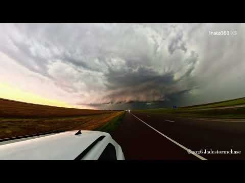
この日の嵐のスピードは自身の想像よりも早く、制限速度の60mph(96km/h)で走っているにもかかわらず一切距離を離せなかったです。
この追われている時の嵐を撮影したものがこの空です。
スーパーセル由来の青と蠢く雲。 まるで碧がこのエリア一帯を捕える牢獄のように覆っています。
The storm was moving faster than I had imagined that day, and even though I was driving at the speed limit of 60 mph (96 km/h), I couldn’t put any distance between us at all.
This photo captures the storm as I was being chased by it.
The blue and swirling clouds of the supercell. It’s as if the azure sky were a prison enveloping the entire area.

狙っていた嵐が勢力を弱めてしまっていたため、別の嵐へとターゲットを変更します。
一番発達しそうなエリアに舵を取りましたが、その前に別の嵐が立ちふさがります。
この目の前の嵐を避けてさらに南西にあるポイントに向かいたいのですが、嵐が速すぎて距離を取ることが出来ません。
南に進路を取り、嵐の際にまで逃げますが、その魔の手は背後にまで迫ってきています。
Since the storm I was targeting had lost some of its strength, I’m switching my focus to another storm.
I set a course for the area that looked most likely to develop into a storm, but another storm blocked my path.
I want to avoid this storm right in front of me and head for a point further to the southwest, but the storm is moving too fast for me to put any distance between us.
I set a course south and escape to the edge of the storm, but its demon hand is closing in on me from behind.

嵐がこちらに近づいており、少しずつ距離を取りながら撮影を行っていました。
雷は近くに落ちると視界がホワイトアウトしてしまい、どこに落ちたか視認するのが難しいことが多いです。
この時もそれが起こりました。 動画で確認するとかなり近くに落雷しており、この画像からもそれが分かるかと思います。
稲妻が空気をかき分けて進む姿は神々しいといっても過言ではないでしょう。
A storm was approaching, so I was filming while gradually moving further away.
When lightning strikes nearby, it often causes a whiteout, making it difficult to see exactly where it struck.
That’s exactly what happened this time. When I checked the video, I saw that the lightning had struck quite close by, as you can probably tell from this image.
It’s no exaggeration to say that the sight of lightning cutting through the air is truly majestic.

今シーズンの最終日、シーズン最高レベルの嵐予報が出ていました。
嵐の発生まで待機し、本命が姿がレーダーに表示されました。レーダーの反応に従い、進路を取ります。
しかし、レーダーの反応に近づくにつれてその圧倒的な威容が認識出来てきます。
地平線を覆うように雲が垂れ下がり、まるで地を吞むように発達していました。
近づいてくるにつれかなりの恐怖を感じていましたが、震える手でその異形を撮影することが出来ました。
On the final day of the season, a storm forecast of the highest intensity of the season had been issued.
We waited until the storm formed, and the main system finally appeared on the radar. We set our course based on the radar readings.
However, as we drew closer to the radar signal, we began to realize just how overwhelmingly massive it was.
Clouds hung low, covering the horizon, and the storm was developing as if it were about to swallow the earth whole.
I felt a considerable sense of fear as we approached, but with trembling hands, I managed to capture that monstrous sight on camera.

背後に迫る嵐から逃げおおせた後、上空に広がるかなとこ雲には嵐の空気の乱れを表わすような波状が形成されていました。
気象においては基本的に様々なバランスが崩れたり、整ったりすることにより、様々な現象が起きます。
この乱れさえも自然にとっては調律の一つなのです。
カオスの中に調律あり。
After escaping the storm that was closing in from behind, wavy patterns formed in the cirrus clouds stretching across the sky, as if reflecting the turbulence of the storm.
In meteorology, various phenomena occur primarily as a result of various balances being disrupted or restored.
Even this turbulence is, in nature’s eyes, a form of harmony.
There is harmony within chaos.

背後に迫る嵐から逃げながら、背後に迫る嵐を撮影。
宙を侵食するように広がっていきます。
雲の内側も不気味に青くなっており、勢力の大きさを物語ります。
While fleeing from the storm closing in behind me, I captured the storm closing in behind me.
It spreads out as if devouring the sky.
The interior of the clouds has taken on an eerie blue hue, a testament to the storm’s immense power.

これからまだ発達するであろう嵐から距離を取り、東へと進路を取る嵐を撮影していました。
写真右側へと進路を取っているのですが、発達していく方向に何度も落雷は発生しています。
残念ながら動くスピードが速すぎたのと、溜まった疲れがどっと押し寄せてしまい、気力が持たなかったのです。
この写真が今チェイスにおける最後の写真になりましたが、発達しきる前の嵐を捉えられたのは良い経験でした。
I was photographing the storm as it moved eastward, keeping my distance from what was likely to become a more intense storm.
Although the storm was heading toward the right side of the photo, lightning strikes were occurring repeatedly in the direction it was developing.
Unfortunately, the storm was moving too fast, and my accumulated fatigue hit me all at once, so I ran out of energy.
This photo turned out to be the last one I took during this chase, but it was a great experience to capture the storm before it fully developed.

背後に迫る嵐から逃げていると、進路に町がありました。
その町を通過している際、他の車もいて混んでいたので踏切で停車しました。
その時の踏切と線路、そして空模様を見たときに感じたのはノスタルジーそのものを感じ、撮影。
この郷愁の気持ちはどこからくるのでしょうか。
As I was fleeing the storm closing in behind me, I came upon a town along my route.
While passing through the town, there were other cars on the road and it was congested, so I stopped at a railroad crossing.
When I looked at the crossing, the tracks, and the sky at that moment, I felt a sense of pure nostalgia, so I took a photo.
I wonder where this feeling of nostalgia comes from.

この日は弱めの嵐のストームの発生予報が立っており、ちょこちょこと遠距離から発生しているのを観測していました。
一つの個体がめきめきと成長していきます。 まるで天に根を張るような成長。
30分もしないうちに自身の上空にまで延びてきました。
A forecast had been issued for a mild storm that day, and I had been observing them forming sporadically in the distance.
One of them grew rapidly. It was as if it were putting down roots in the sky.
In less than 30 minutes, it had extended all the way up to the sky above me.

この日はタルサでのルート66の100周年パレードを午前中に見て、午後はゆっくりする予定でしたが、予想以上に嵐の発達予報が立ったので、
ダッシュでカンザス方面に向けて出立することに。
遠方で早めにスーパーセルが発達していました。
その姿はスーパーセルの典型的な姿であり、美しい巨大積乱雲そのものです。
かなとこ雲が広がり、その最盛期を迎えます。
この後、この雲は力を失い、少しずつ消滅していきます。
We had planned to watch the Route 66 100th Anniversary Parade in Tulsa that morning and take it easy in the afternoon, but since the forecast called for a storm to develop more intensely than expected,
we decided to dash off toward Kansas.
A supercell was already developing in the distance.
It had the classic appearance of a supercell—a beautiful, massive cumulonimbus cloud.
The anvil-shaped cloud spread out, reaching its peak.
After that, the cloud lost its strength and gradually dissipated.

これからまだ発達するであろう嵐から距離を取り、東へと進路を取る嵐を撮影していました。
ストームの核が生きているかのように成長し、円盤状の形を成形しています。
円盤右側が進行方向で、そこの部分が雨が濃いのもお分かりいただけるかと思います。
実のところ、画面右側のエリアが嵐が成長する要素が存在し、このストームはこれから竜巻を生成するストームへと成長するのです。
残念ながら動くスピードが速すぎたのと、溜まった疲れがどっと押し寄せてしまい、気力が持たなかったのです。
この写真が今チェイスにおける最後の写真になりましたが、発達しきる前の嵐を捉えられたのは良い経験でした。
I was photographing the storm as it moved eastward, keeping my distance from what was likely to develop further.
The storm’s core was growing as if it were alive, taking on a disc-like shape.
The right side of the disc is the direction of movement, and I think you can see that the rain is heaviest in that area.
In fact, the area on the right side of the frame contained the elements necessary for the storm to grow, and this storm was on its way to becoming one capable of generating tornadoes.
Unfortunately, the storm was moving too fast, and the fatigue that had been building up hit me all at once, so I ran out of energy.
Although this turned out to be the last photo of this chase, it was a great experience to capture the storm before it had fully developed.

これは厳密にはストームチェイスではないですが、ストームチェイスを終えて拠点のタルサへの帰路についた時、
それはそれは美しい夕日を見ることが出来ました。
嵐が通ったことで空が澄んでいたこと、オクラホマの雄大な光景が生んでくれた夕日です。
ふと昔、祖母と共に夕日が沈むのを見ていたのを思い出してしまいました。
Strictly speaking, this wasn’t a storm chase, but as I was heading back to my base in Tulsa after finishing one,
I was treated to a truly beautiful sunset.
It was a sunset made possible by the clear skies left in the storm’s wake and the majestic scenery of Oklahoma.
It suddenly reminded me of watching the sun set with my grandmother long ago.

この日のチェイスが終わり、連日の疲れを含め、疲れ果てていました。
嵐をガソリンスタンドの駐車場でノックダウンしていました。
嵐が頭上を通り過ぎ、落ち着いていると、スーパーセル後方の乳房雲が姿を見せました。
光の加減もあるのですが、乳房雲の垂れ下がった部分が髑髏のようにも見えました。
そしてそれが潰える様に叫んでいるようにも。
The chase for the day was over, and I was completely exhausted, not just from the day’s events but from the fatigue that had built up over the past few days.
I had pulled over at a gas station parking lot to wait out the storm.
As the storm passed overhead and things settled down, a breast cloud behind the supercell came into view.
It might have been the lighting, but the drooping part of the breast cloud looked like a skull.
And it seemed as if it were screaming as it collapsed.

この日から5日前、私はタルサ、オクラホマを発ち、オクラホマからノースダコタまで一気に北上し、イリノイにまで足を延ばします。
10日ぐらい何もない日が続いていたため、少し焦っていました。(滞在期間の20%何も無ければ焦る気持ちもお分かりいただけるでしょう)
しかし、ノースダコタまで北上したは良いものの道中で食中毒にかかったり、予想に反して予想エリアで嵐が発生しなかったり、
竜巻の発生したエリアまでの道が電信柱でふさがれていたり...
超長距離移動も含めで疲れ果てていました。
結果的に三日間の間、成果としてはほとんど何も撮ることが出来ませんでした。
雷降り注ぐ嵐のコア部分から離脱し、近くのスーパーで休憩していました。
この日の嵐は激しいものでしたので、付随する乳房雲も強大となりました。
褒美と言わないばかりに赤い夕日が大規模な乳房雲を照らし、美しく照らしてくれました。
二年前、人生で初めて見た美しい夕日の乳房雲をもう一度見られるとは思っておらず、いたく感動していました。
Five days prior to this day, I had left Tulsa, Oklahoma, and was heading north in one go from Oklahoma to North Dakota.
Since I’d had about ten days in a row with nothing happening, I was starting to feel a little anxious. (I’m sure you can understand how I felt—after all, if 20% of your trip goes by without anything happening, it’s natural to get anxious.)
However, even though I’d made it all the way up to North Dakota, I came down with food poisoning along the way, storms didn’t form in the expected areas as I’d anticipated,
and the road to the area where a tornado had struck was blocked by downed utility poles...
I was completely exhausted, especially after the extremely long drive.
As a result, I was unable to capture almost anything worthwhile over the course of those three days.
I had pulled away from the core of the storm, where lightning was pouring down, and was taking a break at a nearby supermarket.
Since the storm that day was so intense, the accompanying mammatus clouds were massive.
It was almost like a reward—the red evening sun illuminated the vast mammatus clouds, casting a beautiful glow upon them.
I never expected to see those beautiful mammatus clouds—which I’d first encountered two years ago—again, so I was deeply moved.

この日のチェイスが終わり、連日の疲れを含め、疲れ果てていました。
嵐をガソリンスタンドの駐車場でノックダウンしていました。
嵐が頭上を通り過ぎ、落ち着いていると、スーパーセル後方の乳房雲が姿を見せました。
嵐の核方面と晴れて光を取り戻しつつあるその境界。
After the chase that day was over, I was completely exhausted, not just from the chase itself but also from the fatigue that had built up over the past few days.
I had pulled over in the gas station parking lot to wait out the storm.
As the storm passed overhead and things settled down, a lenticular cloud behind the supercell came into view.
The boundary between the storm’s core and the clear sky, which was gradually regaining its brightness.

嵐の麓にまで潜り込み、位置を変えながらターゲットを絞っていきます。
その際、とある一つの嵐の核近くにまで接近しますが、かなり地面の方に壁雲が伸びていました。
幸い、この嵐は回転する力が弱かったため、竜巻を発生させることは無かったですが、不気味な光景でした。
I made my way right up to the base of the storm, changing my position as I narrowed in on my target.
In the process, I got close to the core of one particular storm, where wall clouds were extending quite far down toward the ground.
Fortunately, this storm’s rotational force was weak, so it didn’t produce a tornado, but it was an eerie sight.

大規模ストームが予想されたこの日、かなり早い段階から第一波のストームが迫ってきていました。
荒れる上空とその奥に大規模な棚雲の構造、緑の空が広がっています。
しかしこれはまだ前哨戦。 この後に第二波がやってきます。
On this day, when a major storm was forecast, the first wave of the storm was already approaching quite early on.
The sky is turbulent, with a massive shelf cloud formation stretching out beyond it, and a green expanse of sky spreading out.
But this is just the prelude. The second wave is coming next.

この日はカンザスシティ西部にストーム発生予報が立っており、先日のイリノイからの連戦で疲弊しながらも向かうことになりました。
ストームの南側から接近する形となり、発達した嵐が遠方から見えてきます。
写真を撮影している間も成長を続けており、画像真ん中に斜めに成長する筒のようなものが分かると思います。
ここが嵐の中心部であり、ここまではっきり筒状のものが見えるのは珍しいです。
A storm warning had been issued for western Kansas City that day, so we decided to head there despite being exhausted from our recent back-to-back games in Illinois.
We approached from the south side of the storm, and we could see the developing storm in the distance.
It continued to grow even as I was taking photos; you can probably make out a tube-like structure extending diagonally in the center of the image.
This is the center of the storm, and it’s rare to see such a distinct tube-shaped structure this clearly.

この日は弱めの嵐発生が予想されていており、結果的には構造体的な物は見られませんでした。
しかし、それに付随する乳房雲の観測を行えました。
晴れ間の間に見える乳房雲も美しい。
A mild storm was forecast for that day, and as it turned out, no structured cloud formations were observed.
However, we were able to observe the associated mammatus clouds.
Mammatus clouds are beautiful even when visible through breaks in the clouds.

荒房 rough mamma
この日は弱めの嵐発生が予想されていており、結果的には構造体的な物は見られませんでした。
しかし、それに付随する乳房雲の観測を行えました。
晴れ間の間に見える乳房雲も美しい。
A mild storm was forecast for that day, and as it turned out, no structured cloud formations were observed.
However, we were able to observe the associated mammatus clouds.
Mammatus clouds are beautiful even when visible through breaks in the clouds.

この日から5日前、私はタルサ、オクラホマを発ち、オクラホマからノースダコタまで一気に北上し、そしてイリノイにまで足を延ばします。
10日ぐらい何もない日が続いていたため、少し焦っていました。(滞在期間の20%何も無ければ焦る気持ちもお分かりいただけるでしょう)
しかし、ノースダコタまで北上したは良いものの道中で食中毒にかかったり、予想に反して予想エリアで嵐が発生しなかったりで散々でした。
この日、アイオワでイリノイの嵐発生エリアに向かっていると、まるでUFOのような形の雲が顔をのぞかせているではないですか。
きっとこの円盤のせいで不幸が...(責任転換)
Five days prior to this, I left Tulsa, Oklahoma, and headed straight north from Oklahoma to North Dakota, then continued on to Illinois.
Since I’d had about ten days in a row with nothing happening, I was starting to feel a little anxious. (If 20% of your trip goes by without anything happening, I’m sure you can understand that feeling.)
However, even though I made it all the way up to North Dakota, the trip was a disaster—I came down with food poisoning along the way, and contrary to my expectations, no storms formed in the areas I’d targeted.
On this day, as I was heading from Iowa toward the storm-prone area in Illinois, wouldn’t you know it—a cloud shaped just like a UFO peeked out.
I’m sure this flying saucer was the cause of my misfortune... (shifting the blame)

この日のチェイスが終わり、連日の疲れを含め、疲れ果てていました。
嵐をガソリンスタンドの駐車場でノックダウンしていました。
全てが落ち着き、その中で夕日が美しいダブルレインボーを作り上げます。
After the chase that day was over, I was completely exhausted, not just from the chase itself but also from the fatigue of the past few days.
I had pulled over the Arashi in the parking lot of a gas station.
As everything settled down, the setting sun created a beautiful double rainbow.

ストームのコアから少し距離を取り、コアの全貌を撮影
夕日とスーパーセルからの緑-青を同じ画角に収めており、その美しいグラデーションを感じられます
嵐本体の悍ましさと、そこから生み出される美しさ
スーパーセルの下は神の領域といっても差し支えはないでしょう
I positioned myself a short distance from the storm’s core to capture its full extent.
The photo frames both the setting sun and the green-blue hues from the supercell within the same field of view, allowing you to appreciate the beautiful gradient.
The ferocity of the storm itself and the beauty it creates—
It would be no exaggeration to say that the area beneath a supercell is a realm of the divine.

嵐はその威容を保ったままこちらへと接近してきます。
実際に見ると言葉にならない感動がこみ上げてきますが、それと同時に恐怖も湧いてきます。
この嵐は私が離脱した後、砂嵐を起こし、大規模なハブーブとなりました。
私も巻き込まれ、視界が0となり、動くことが出来ませんでした。
The storm approaches us, still maintaining its imposing presence.
Seeing it in person fills me with an indescribable sense of awe, but at the same time, fear wells up inside me.
After I left, this storm kicked up a sandstorm and turned into a massive haboob.
I got caught up in it too; my visibility dropped to zero, and I couldn’t move.

この日は2026年ストームチェイスの初戦となり、かつ三日間の連続チェイスの初日でした。
ストームコアが発生したのを確認するとともに接近していくのですが、道中に引き伸ばされた乳房雲が。
今年のチェイスで初の乳房雲だったので嬉しかったのと、翼のような形をしていたのもポイントが高いです。
上空の彼方にいるのに、この巨大さが伝わるでしょうか。
This day marked the first storm chase of 2026, as well as the first day of a three-day consecutive chase.
As we confirmed the formation of a storm core and moved closer to it, we spotted an elongated mammary cloud along the way.
I was thrilled because it was the first mammary cloud I’d seen on this year’s chase, and the fact that it was shaped like a wing was a definite highlight.

碧玉の空が去り、スーパーセルの降雨部分が上空を通り抜け、スーパーセルの背部が上空に広がります。
そこに広がっていたのは上空を埋め尽くす乳房雲。
過去に私が見てきた中でも一番形がくっきりとしていました。
不気味にも見えますが、そこにあるのは柔らかな安心感と嵐の終わりを告げる安寧です。
陽に柔らかく照らされるその姿には包まれるような安心感を感じられます。
As the jade sky faded away, the rain band of the supercell passed overhead, and the rear of the supercell spread out above.
Spreading out there were mammatus clouds that filled the sky.
They were the most distinctly shaped I’ve ever seen.
Though they may look eerie, what they convey is a gentle sense of security and the tranquility that heralds the end of the storm.
Gently illuminated by the sun, this sight offers a sense of security that feels almost enveloping.

この日の乳房雲は長期間上空に形を保ち続けており、一時間近く観察を続けられました。
嵐を潜り抜けた安心感を与えてくれています。
上空一面に広がっているその姿は神々しいとまで言えるでしょう。
The cumulus clouds that day maintained their shape in the sky for a long time, and we were able to observe them for nearly an hour.
They give us a sense of relief, as if we’ve weathered a storm.
Spreading across the entire sky, their appearance could even be described as divine.

先ほどの西側から迫る嵐を一度避け、次の嵐を待ち構えます。
空全体がスーパーセル由来の緑に包まれますが、先ほど以上の嵐の発達はありませんでした。
しかし、休憩がてら待っていると特段緑が濃いエリアが近づいてきます。
碧玉のように美しい色ですが、それは危険の裏返し。
すぐに建物内に避難すると、バケツをひっくり返すような大雨になってしまいます。
After evading the storm that was approaching from the west a moment ago, I waited for the next one.
The entire sky was enveloped in the green glow of a supercell, but the storm didn’t develop any further than it had before.
However, as we waited and took a break, an area with an unusually deep green hue began to approach.
The color was as beautiful as jade, but that beauty was the flip side of danger.
I immediately took shelter inside a building, just as torrential rain began to pour down like buckets being overturned.

スーパーセル、というよりは自然というのは不思議なもので数分でも同じ雲を見ていても色や形が目まぐるしく変わります。
これを撮ったときはスーパーセル由来の青色は見えず、雲の暗部が目立ちました。
それに高速で雲も蠢き、撮影をしながら観察をしていましたが、移動をしようと車に機材を入れていると、
透明な筒が木や葉っぱを巻き上げこちらに突っ込んでくるではありませんか。
透明で音もなく、竜巻の魔の手はこちらに近づいていたのです。
いざ本当にヤバくなると人というのは動けないものです。
幸い、目の前で竜巻は霧散し、ケガもなく変えることが出来ましたが、もし発達していたら...
Nature is a mysterious thing—even when watching the same cloud for just a few minutes, its color and shape change rapidly.
When I took this photo, I couldn’t see the blue hue typical of a supercell; instead, the dark areas of the cloud stood out.
The clouds were also shifting rapidly. I was observing them while taking photos, but just as I was packing my equipment into the car to leave,
a transparent column suddenly swept up trees and leaves and barreled straight toward me.
Transparent and silent, the tornado’s menacing grasp was closing in on me.
When things get really dangerous, people tend to freeze up.
Fortunately, the tornado dissipated right before my eyes, and I was able to get away unharmed, but if it had continued to develop...

連戦三日目
この日は特にストーム発生確率が特に高い危険日でした。
竜巻警報が出ている嵐を追う形を取り、スーパーセルのアップドラフト部を背後から撮影しました。
その姿はまるで天に上る龍のようでもあり、葛飾北斎の波のようにも見えます。
普段は雲に隠れてしまい、その姿を見ることはあまり出来ないのですが、今回は運よく視認が出来ました。
Day Three of the Storm Chasing Expedition
This was a particularly dangerous day with a very high probability of storms forming.
I chased a storm for which a tornado warning had been issued and captured footage of the updraft of a supercell from behind.
Its appearance resembled both a dragon ascending to the heavens and Katsushika Hokusai’s “The Great Wave.”
It’s usually hidden by clouds, so we rarely get to see it, but this time we were lucky enough to spot it.

ストームのコアへと進路を取り、その真下にまで侵入しました。
そこら中に雷が落ち、こちらに当たるか当たらないかは完全に運頼みになっています。
そのうちの一本は落ちると思いきや再び雲の中へ。
地上に到達するにもそれなりに気合が必要なのかもしれません。
We set a course toward the core of the storm and penetrated right beneath it.
Lightning is striking all around us, and whether it hits us or not is entirely up to chance.
Just when I thought one of the bolts was about to strike, it vanished back into the clouds.
Perhaps it takes a fair amount of determination just to reach the ground.

この日は個人的に少し特殊なチェイスとなりました。
ある日本人の気象研究者の方と共にストームチェイスことになったんですね。
以前からお話をしていて、オクラホマ~テキサスの方面でストームの予報が立った際にチェイスをすることになっていました。
ちょうどこの時、テキサス北部でストームの予報が立っており、タイミングも合致したので人生で初めて他の方と共にチェイスしました。
雷雨と雹がメインのストームでしたが、威圧感は圧倒的。弓のようにしなる形の棚雲とその奥の暗黒は見る物を圧倒します。
そこそこ良いものが見れたこともあり、研究者の方とも交流が出来てとても楽しめた日でした。
This particular day turned out to be a somewhat unique storm chase for me personally.
I ended up going on a storm chase with a Japanese meteorological researcher.
We’d been talking about it for a while, and had agreed to chase storms together whenever forecasts called for them in the Oklahoma–Texas area.
At that very moment, storms were forecast for northern Texas, and since the timing worked out, I went on my first-ever storm chase with someone else.
Although the storm consisted mainly of thunderstorms and hail, its presence was overwhelming. The arched shelf clouds and the darkness beyond them were truly awe-inspiring.
I got to see some pretty impressive sights, and I also had the chance to interact with the researcher, so it was a day I thoroughly enjoyed.

コアのうねりが見えるところからほんの少し離れた場所で観察を続けています。
雨柱が観察出来て満足していたのですが、どうも雨に隠れていただけで竜巻が発生していたようです。
EFU Gooodland 竜巻 幸いこのエリアはほとんど建物が無いエリアでしたので、被害もほとんどなかったみたいです。
May 16, 2026, Kansas Goodland The Pillar—EFU Goodland Tornado
I’m continuing to observe from a spot just a short distance away from where the core’s undulations are visible.
I was satisfied with seeing the rain column, but it seems a tornado had actually formed—it was just hidden by the rain.
EFU Goodland Tornado: Fortunately, there were almost no buildings in this area, so it appears there was very little damage.

先日のカンザス北西部からネブラスカ中部へ移動して二日目のチェイスに移行します。
自身が待機していた地点から西側にフックエコーを持ったスーパーセルが発生します。
嵐は東側に進路を取っていたため、待ち構える形をとりました。
待ち構えるだけでもこちらに近づいてくる巨大な嵐は何度見てもなれません。
西日とスーパーセルが由来の青が対照的に映し出されます。
Moving on to the second day of our chase, which took us from northwestern Kansas to central Nebraska.
A supercell with a hook echo formed to the west of where I was stationed.
Since the storm was heading east, I took up a waiting position.
No matter how many times I see it, I never get used to the sight of a massive storm approaching even while I’m just waiting for it.
The setting sun and the blue hues from the supercell create a striking contrast.

Goodlandのスーパーセルが起こしていたハブーブと頭上に発生した雹を降らせるコアを何とか潜り抜け、その反対側へと抜けました。
夕日に映し出された乳房雲とスーパーセルの美しさはストームチェイサーのご褒美です。
I managed to navigate through the haboob caused by the Goodland supercell and the hail-producing core that had formed overhead, and emerged on the other side.
The beauty of the mammatus clouds and the supercell bathed in the setting sun is a reward for storm chasers.

連戦三日目かつ、この日は渋滞もひどく体力を使い果たしてしまいました。
竜巻を発生させるストームにも追いつけないので、休憩がてら近くの駐車場で休んでいたのですが、
また別のストームがこちらへ近づいていました。
湿度の高い上空で円盤状のストームがこちらに近づいていたのです。
朧ながらも神々しさを感じました。 そのあとは土砂降りでしばらくは動けませんでしたが、満足のいく一枚でもあります。
It was the third day in a row of back-to-back shoots, and with the terrible traffic that day, I was completely exhausted.
Since I couldn’t keep up with the storm that was generating tornadoes, I stopped at a nearby parking lot to rest, but
another storm was approaching.
A disc-shaped storm was drawing closer in the humid upper atmosphere.
I sensed a sense of divinity, however faint. After that, a downpour hit, and I couldn’t move for a while, but this is still a shot I’m very satisfied with.